

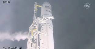
Following an earlier glitch caused by a fire alarm at the mission operations control center in Dulles, Virginia, Uganda’s first-ever satellite, PearlAfricaSat-1 has finally been launched successfully.
On Sunday afternoon, the launch was interrupted by a technical glitch that saw America’s National Aeronautics and Space Administration (NASA) postpone it.
On Monday, the satellite was successfully launched in a five-minute window that opened at 5:27 a.m. EST(1:27pm EAT).
About the satellite
The satellite developed by Ugandan engineers Edgar Mujuni, Bonny Omara, and Derrick Tebusweke is part of the BIRDS program, a cross-border interdisciplinary satellite project for non-space faring countries supported by Japan.
It follows Uganda’s agreement with Kyushu Institute of Technology (Kyutech) in Japan which involved upskilling the three graduate engineers to design, build, test, and launch Uganda’s first satellite.
It is a joint project between Uganda and Japan.
The satellite is loaded with more than 8,200 pounds of research, crew supplies, and hardware.
It will help provide research and observation data in six primary areas including weather forecast; land, water and mineral mapping; agriculture monitoring; infrastructure planning; border security, and disaster prevention.
By being launched to the space, the satellite will aid in research investigations including a facility to advance 3D biological printing of human tissue in space, a study taking advantage of microgravity to better understand catastrophic mudflows that can occur after wildfires, an investigation into how microgravity influences ovary function and an experiment that studies if changes space-grown plants undergo to adapt to microgravity can be transmitted through seeds to the next generation.
In particular, the PearlAfricaSat-1 will provide about 20-metre resolution images for Uganda to facilitate water quality, soil fertility, and land use and cover analysis.
The statistical data collected by the satellite will also help distinguish bare ground from forest and farmland and possibly indicate the quality of agricultural growth to improve the livelihood of citizens in the country.
The satellite will play a vital role in the oil and gas operation by monitoring the East African crude oil pipeline. This will enable accurate weather forecasts by gathering remote sensor data for predicting landslides and drought.